SmartFabric
- Print
- DarkLight
- PDF
SmartFabric
- Print
- DarkLight
- PDF
Article summary
Did you find this summary helpful?
Thank you for your feedback!
Overview.PNG)
SmartFabricSM is the most comprehensive and accurate property dataset available, designed to power your applications and analytics with unmatched precision.
With 154 million parcels, 160 million assessment records, 150 million building footprints, and 265 million addresses, SmartFabric provides a complete national property universe. Backed by 40 years of sales transactions and seamlessly integrated with the LightBox ID, this dataset ensures seamless data connectivity and superior accuracy, making it an essential tool for businesses that rely on precise geospatial data.
This dataset can be used to solve many business challenges such as data center site selection, insurance underwriting, telecommunications network planning, utility risk analysis, commercial real estate workflows and much more.
SmartFabric provides the needed dataset for solutions that require a high level of fidelity and location accuracy over a large area, including rural areas. LightBox builds SmartFabric, utilizing four core data sets: building footprints, parcels, address information and assessor data.
Unlock the Full LightBox Data Ecosystem with LightBox ID
At the core of SmartFabric is the LightBox ID, a persistent, unique identifier that connects data across multiple sources to deliver unmatched consistency and reliability. With SmartFabric, you gain access to the entire LightBox data ecosystem, including SmartFabric add-ons below:
True OwnerSM – Access curated ownership records for informed decision-making.
Zoning Data – Gain insights into land use, restrictions, and development potential.
Historical Transaction – Analyze 40 years of property sales data for trend analysis.
Business Listing (POI) – Identify commercial properties and their tenants with ease.
Builder Site – Track new developments and construction activity.
By leveraging LightBox ID, SmartFabric seamlessly links these datasets, unlocking a complete, end-to-end workflow for real estate decision-making, from site selection and market analysis to investment strategy and risk assessment.
Components
SmartFabric products are broken down into packages with the package you choose depends on your use case.
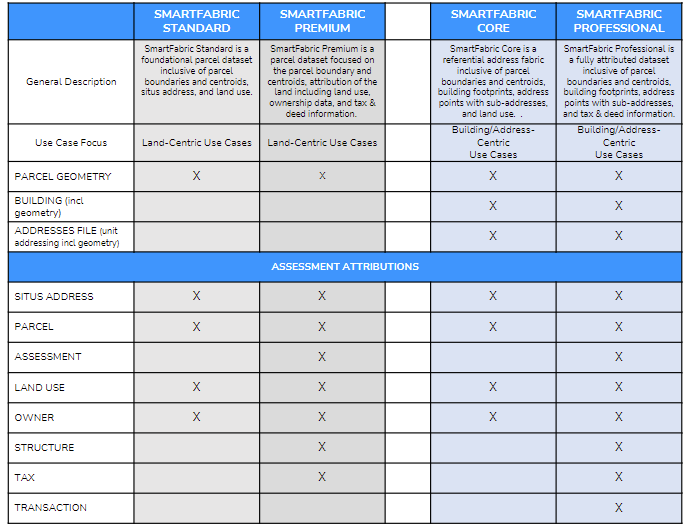
Geospatial layers
Geospatial layers can include the following, depending on which licensed package you use:
Relationship tables
These tables are included in the core and professional packages
AddressAssessmentRelationAddressBuildingRelation
AddressParcelRelation
BuildingAssessmentRelation
BuildingParcelRelation
ParcelAssessmentRelation
See SmartFabric Relationship Tables for more information around these relationship tables
FAQs
See Frequently Asked Questions
Copyrights
© 2025 LightBox Holdings, L.P All rights reserved.
© Copyright United States Postal Service. All rights reserved.
© HERE, 3rd party notifications - Click here for more information.
Was this article helpful?