Layer Options
- Print
- DarkLight
- PDF
Layer Options
- Print
- DarkLight
- PDF
Article summary
Did you find this summary helpful?
Thank you for your feedback!
The layer options can be found next to most layers in the layer's menu by selecting the gear icon:
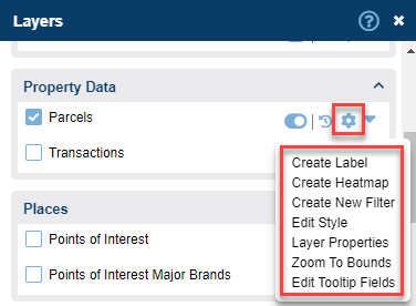
Create Label | Provides the ability to create labels to display data on the map. Only one label at a time can be displayed. |
Create Heatmap | Visualize the layer as a heatmap |
Create New Filter | Create a new filter to search the layer or dataset |
Edit Style | Provides the ability to edit or change the layer style |
Layer Properties | This option opens up the Layer Properties Window which allows you to organize your data, assign layers to existing groups, or create new groups |
Zoom to Bounds | Sets the map extent to the boundary of the selected layer |
Edit Tooltip Fields | Allows for the tooltip display options to be modified per layer. Learn more here. |
Extract | Certain layers can have their shapes (but not attributes) extracted to a shapefile. Default layers cannot be extracted. |
Was this article helpful?