Zoning FAQ
- Print
- DarkLight
- PDF
Zoning FAQ
- Print
- DarkLight
- PDF
Article summary
Did you find this summary helpful?
Thank you for your feedback!
Q: Where do the Zoning codes come from?
A: They are sourced from governing jurisdictions. This can be a county, a city, or county subdivision.
Q: How does the search filter for Zoning work?
A: The standalone search filter dedicated to searching for just the Zoning details, identifies the data based off the fields of information that Lightbox acquires from counties and cities within the Zoning Boundary layer. Please see the associated documentation for more details on the Zoning here. If you’re on the Builder or Enterprise edition of LightBox Vision, then the zoning search is included within the Property Search and Advanced Property search filters and allows for a search by zoning code or category alongside the property information.
Q: Can I see the zoning information on a report?
A: If your account is subscribed to the Commercial or Builder version of LightBox Vision, then zoning will appear as an option to use within the Site Profile Report. Enterprise accounts do not have access to this kind of report but if it’s desired, please contact your account manager to look in to upgrading to the Commercial or Builder version.
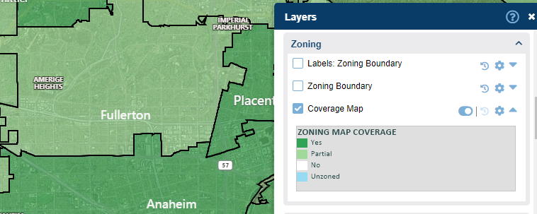
Q: What is the Coverage Map layer?
A: The Coverage Map layer shows a visual overlay of the areas that we may or may not get Zoning data for. Expand the legend of that layer and you will see the color-coded references:
Dark Green = Yes (Coverage area available by Lightbox)
Light Green = Partial (Coverage area partially available by Lightbox.)
White = No (Coverage area not provided by Lightbox)
Light Blue = Unzoned (LightBox confirmed that this jurisdiction has no zoning governance at this time)
Q: What does ‘partial’ mean in the Coverage Map layer?
A: A Zoning boundary file that we acquire for one jurisdiction often covers parts of neighboring jurisdictions as well. Image example below:
Q: What does the Zoning Category mean and where do they come from?
A: Lightbox generates the standardized categories by analyzing the Zoning description and Zoning district. Currently the categories are:
Residential
Commercial
Industrial
Agriculture
Open Space/Parks
Public
Specific Purpose
Planned Development
Mixed Use
Overlay
Other
Unknown
Q: How often is the Zoning data updated?
A: Update frequency is based on a jurisdiction’s population size. For jurisdictions with population > 100k, updated every quarter. For jurisdictions with population < 100k, updated every other quarter. Updated Zoning data is released on a quarterly basis for reflecting changes.
Q: How can I tell when the Zoning was last updated?
A: To view these dates, select your parcel of interest and choose to View Details under the Zoning card to see the Ordinance As Of date and Boundary As Of date
Ordinance Date: The date of which that jurisdiction published the ordinance
Boundary Date: The date of which that jurisdiction published the boundary
Q: If a parcel has more than one Zoning code on it, what does it mean?
A: A parcel can be governed by multiple Zones. Most commonly, one is base Zoning, others are Zoning overlays. A parcel can also be governed by multiple jurisdictions. Each jurisdiction may have their own Zoning governance for this parcel. You may see multiple Zoning records associated with the same parcel.
Q: What does a PZR Zoning Report look like if I purchase it?
A: Please see an example PDF here.
Q: If a discrepancy is found who should be notified?
A: Please provide Support with the full address and APN of the property and summarize the concern so it can be investigated.
Was this article helpful?