- Print
- DarkLight
- PDF
Area of Interest (AOI) Tool
- Print
- DarkLight
- PDF
Overview
The AOI Tool is the first mapped-based technological solution to help identify adjoining properties per the adjoining property language in ASTM 1527-21.
“3.2.4 adjoining properties, n—any real property or properties the border of which is contiguous or partially contiguous with that of the subject property, or that would be contiguous or partially contiguous with that of the subject property but for a street, road, or other public thoroughfare separating them.”
Using the LightBox SmartFabric of tax parcels, building footprints and ownership information, as well as street networks, the AOI tool displays the boundary of the adjoining properties and flags environmental records within the area.
Step 1: Open the AOI Tool
To begin using the AOI Tool, open LightBox Live, click the Tools button in the top right corner and select AOI Tool.
Step 2: Add Buffers
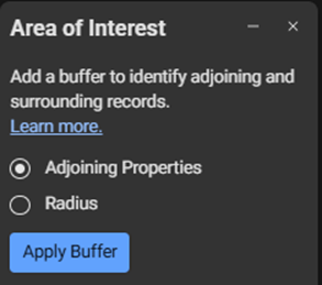
The AOI Tool offers both ready-made and custom buffers for identifying adjoining and surrounding properties.
 The “Adjoining Properties” buffer applies advanced mapping techniques developed by LightBox to help identify adjoining properties when performing Phase I Environmental Site Assessments. The “Adjoining Properties” buffer takes into consideration the "adjoining property" definition in ASTM E1527-21. The proprietary method developed by LightBox identifies adjoining properties based on data from the LightBox SmartFabric™ of geospatially enabled tax parcels, property ownership records, and building footprints, as well as street networks.
 “Radius” applies a customer-specified distance and identifies intersecting tax parcels from the LightBox SmartFabric of geospatial data.
Click Apply Buffer.
Step 3: View Results
Results are displayed on the map and within applicable lists.
The buffer line on the map indicates the geographic boundary of the results.
In each applicable list, blue chevrons (
.png) ) indicate which records fall within the buffer area. Applicable lists include, where available: Government Records, Assessor Records, and Building Permits. The blue chevron (
) indicate which records fall within the buffer area. Applicable lists include, where available: Government Records, Assessor Records, and Building Permits. The blue chevron (.png) ) symbol may be edited to help you refine the results. Note that if you click Apply again, the results may override any edits you have previously made.
) symbol may be edited to help you refine the results. Note that if you click Apply again, the results may override any edits you have previously made.
Step 4: Analyze Property Data
Using the AOI Tool, you can perform detailed property analyses to help do accurate and comprehensive site assessments.
Overlay the buffer area on current and historical maps: Tax Parcels, Sanborn Maps, Aerial Photos, and Topographic Maps.
Intersect the buffer area with record lists: Government Records, Assessor Records, and Building Permits.
Filter results to focus on specific records.
Export content for further analysis and reporting.
.png)

.png)