Commands & Quick Links
- Print
- DarkLight
- PDF
Commands & Quick Links
- Print
- DarkLight
- PDF
Article summary
Did you find this summary helpful?
Thank you for your feedback!
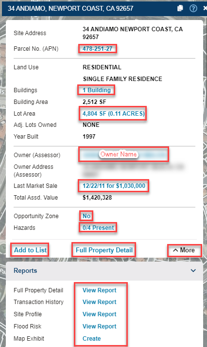
The Commands and Quick Links are the blue links located on the cards within the Information Panel that appears when a parcel is selected. They provide users the ability to perform single property analysis and gather more information on a site. Learn more about each below.
Commands & Quick Links
| Add to List | Adds the selected record to the results list for the layer |
| Adj. Lots Owned | If the property owner owns adjacent lots, the number of lots and sum of their acreage will be shown in a blue link. Click the link to add the adjacent lots owned to a results list, and display on the map. |
| APN | Selecting the link on the APN will generate a Full Property Detail Report |
| Bird's Eye | Opens a bird's eye, oblique, or aerial image of the selected property in a separate window Note: Bird's eye is sourced from Microsoft Bing Maps and may not be available at all locations |
| Buildings | Selecting the link for Buildings will enable the Buildings Layer (Zoom level must be within 100ft overhead to view this layer) |
| Copy Geometry | Copies the selected record's geometry to another layer |
| Create Map Exhibit* | Allows users to easily create a map exhibit of retail logos in the surrounding area |
| Document Images** | Available as an add-on, allows users to access the Deed documents for properties. |
| Edit Attributes | Allows changes to the field attributes for the markup layer |
| Edit Geometry | Allows the geometry of the selected feature to be edited and requires write access to the selected layer |
| Exclude Area | Allows the geometry of the selected feature to be excluded from the search filter. An optional buffer can be applied around the feature to exclude a specified radius around the feature. |
| Find Comparables* | Allows the user to choose a property and use the attributes of that property to find similar properties. This functionality works across county lines. |
| Full Property Detail | Choosing this link generates a report on a parcel that may contain site information provided via county assessor Note: Available fields are dependent on a per county basis with what they record and submit to third parties |
| Hazards | Selecting this link provides a secondary information panel with possible hazard information to see details on (ex: Flood, Wetlands, Superfund Sites, etc) |
| Last Market Sale | Selecting this link generates a Transaction History Report on the parcel if available |
| List Units | Adds all additional records or units at the property to a list. This is an applicable command when there are multiple addresses or properties that are found on a master parcel. This is useful when researching shopping centers with a range of addresses or condos. |
| Measure / Lot Area | Allows the selected feature to have measurements turn on or off. The measurement is static and will stay on that parcel until the command is clicked again. |
| Opportunity Zone | Selecting this link enables the Qualified Opportunity Zone layer to be visible on the map view |
| Owner Lookup | Selecting this option takes you to the website: www.CorporationWiki.com which provides Owner information from the Secretary of State |
| Owner Portfolio* | Adds all properties that share ownership to a list. |
| Property Detail Report | Displays a printable report of the full property details |
| Search Area | Allows the user to restrict the search to the selected property and add an applied buffer or radius around the property. |
| Seller Lookup | Selecting this option takes you to the website: www.CorporationWiki.com which provides Seller information from the Secretary of State |
| Shared Documents | Allows users to upload and share documents at a location, between everyone in their organization |
| Shared Notes | Allows users to write and share notes at a location, between everyone tied to the same company's LightBox Vision account |
| Site Profile Report | Allows the user to create a customizable PDF report that includes various details of a property including transaction history, property details, demographics data (within a defined trade area, or drive time), and more |
| Tax Map** | Available as an add on, this feature downloads an exact copy of the assessor tax map from a third party who retrieves these from the county |
| Traffic | Selecting this link enables the Traffic 2017 layer on the map view |
| Transaction History | Opens a new page with the transaction history for the property, shows all recent arms length and non-arms length transfers |
Note:
*This command is only available in the LightBox Vision Commercial Real Estate and Builder Developer Editions.
**This command is available as a premium add-on. Contact your Account Manager for more info.
**This command is available as a premium add-on. Contact your Account Manager for more info.
Was this article helpful?