- Print
- DarkLight
- PDF
About the Data
- Print
- DarkLight
- PDF
The About The Data cards are designed to provide insight on some of the different data-sets in LightBox Vision including: Parcel Data, Points of Interest, Demographics, and others. This information can be found by expanding the "About the Data" card located at the bottom of their respective Location Information Panels. Read below to learn about the different data sets, and the definitions of the fields displayed.
Note:
Demographics and Points of Interest data do not come standard in all versions of LightBox Vision. Please contact your account manager for more information.
About the Data for Parcel (Assessor Data)
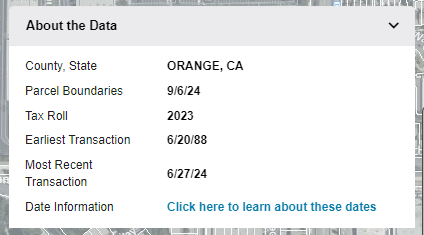
The About The Data card was designed to provide insight on some of the different property datasets in LightBox Vision. All the dates included in the information are representative of the county that the parcel resides in. This information will vary by county, but will remain static for any parcel within a given county. This information can be found by expanding the About the Data card located at the bottom of the Location Information Panel. Read below to learn about the definitions of the fields displayed.
Note:
The below example is for referencing our main assessor data. The About the Data card will be in the same location on the Information Panel of other layers for visibility when enabled from the Layer's Menu

Parcel Boundaries | The Parcel Boundaries date represents the version date provided by either a county’s GIS department or other data provider. Any changes after this date will be reflected in the next update cycle which, on average, can occur annually. A "version date" is the date that the County GIS office or a data provider has last updated the data in their systems. |
Tax Roll | The Tax Roll date represents the tax year when the property was last assessed by the County Assessor. Updates to this information are expected to happen annually, or biannually, depending on the county that it represents. |
Earliest Transaction | This reflects the earliest transaction recording date for the county that can be found in our database. |
Most Recent Transaction | The Most Recent Transaction date represents the latest recording date currently in our database for the county. There is additional time that it takes a transaction to get recorded and processed which may result in a delay of a few weeks between when a transaction takes place and when it appears in the LightBox Vision product. |
.png)

.png)