Zoning FAQ
- Print
- DarkLight
- PDF
Zoning FAQ
- Print
- DarkLight
- PDF
Article summary
Did you find this summary helpful?
Thank you for your feedback!
Q: Where can I find your zoning data coverage?
A: For each release, we will have a summary of data coverage in the release notes. You can find the detailed coverage information through the Zoning coverage map.
Q: How does LightBox handle zoning overlay conflicts?
A. Our methodology when processing zoning data is that we leave it true to the source. LightBox does not make any judgment call when an overlay conflict occurs. If you find a overlay conflict you should contact the zoning source which we provide.
Q: Why are there multiple records with the same PARCEL_LID in the zoning table?
A.1: It is possible for a single parcel to be governed by multiple zones. Most commonly, one of the zones is the base zoning code, and the others are zoning overlays.
A.2: A parcel can also be governed by multiple jurisdictions. Each jurisdiction may have their own zoning governance for the parcel.
In both cases above, you will see multiple zoning records with the same PARCEL_LID.
Pro Tip:
Using the INTERSECT_PCT percent field can give you signal about how much percentage of the parcel lands in the specific zone from a record.
Q: How is INTERSECT_PCT field calculated?
A: INTERSECT_PCT is calculated by overlaying a parcel boundary with a zoning boundary from a jurisdiction and using the percent area that is covered by that boundary as the value.
Pro Tip:
Keep in mind that the parcel dataset and the zoning boundary dataset are typically created separately and may not always align exactly with the parcel. Understanding this you might find that there are some parcels that have a very small INTERSECT_PCT value (< 4) . Using this field and a tolerance that you are comfortable with records can be removed to provide a smaller dataset size.
Q: What to do if a jurisdiction needed is not yet covered in the dataset?
A: Our zoning coverage will expand overtime based on many factors, one such factor is that of client needs. When you sign on or renew your zoning data subscription, we encourage you to provide a list of jurisdictions (<20) that are most important to your business. Those requests are taken into consideration during our acquisition efforts.
There are many reasons why we do not carry a jurisdiction:
- The zoning data is not available in a digital format.
- The jurisdiction does not release their zoning data in a consumable format.
- LightBox has yet to acquire that jurisdiction.
Q: Can I search for properties zoned for a specific type?
A: Once zoning data is linked to parcel via PARCEL_LID, users can search for parcels that meet a specific zoning criteria from the attributions we standardized.
Examples: ZONING_CATEGORY, FRONT_SETBACK_IN_FEET, PERMITTED_USES.
Pro Tip:
Before making a database join from the zoning table to the parcel table create an attribute index on the PARCEL_LID in both the parcel table and the zoning table to optimize the join.
Q: What does the Zoning Category mean and how is it derived?
A: LightBox generates standardized zoning categories by analyzing keywords in the zoning description and zoning district fields.
Currently we have 12 zoning categories:
- Residential
- Commercial
- Industrial
- Agriculture
- Open Space/Parks
- Public
- Specific Purpose
- Planned Development
- Mixed Use
- Overlay
- Other
- Unknown
Pro Tip
Zoning codes are developed and maintained by each jurisdiction. This means that each zoning code can be slightly or completely different between jurisdictions. Using the LightBox zoning category allows for cross jurisdiction search.
Warning:
Since zoning is maintained at the jurisdiction level, two neighboring jurisdictions might have the same code but different values in the setback, FAR, building heights etc.
Q: Can I search for properties zoned for a specific type?
A: Once zoning data is linked to parcel via PARCEL_LID, users can search for parcels that meet a specific zoning criteria from the attributions we standardized.
Examples: ZONING_CATEGORY, FRONT_SETBACK_IN_FEET, PERMITTED_USES.
Pro Tip:
Before making a database join from the zoning table to the parcel table, create an attribute index on the PARCEL_LID in both the parcel table and the zoning table to optimize the join.
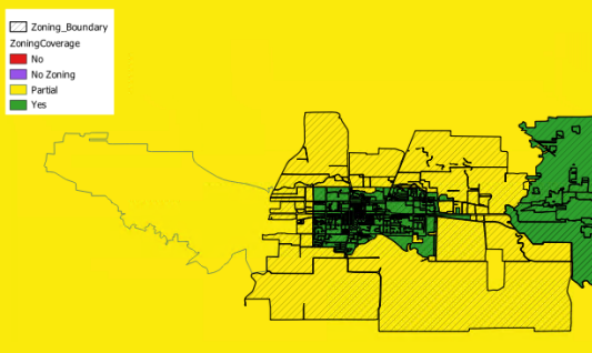
Q: What does ‘partial’ mean in the coverage map?
A: Zoning boundary data that we acquire for one jurisdiction often covers parts of neighboring jurisdictions as well.
In the example below, the zoning boundary file for the city in the center covers parts of the city on the left and county (surrounding area). In this case, the city on the left and county are both considered partial coverage.
Q: What projection or spatial reference is the Zoning Boundary and Zoning Coverage in?
A: The data is delivered in the WGS 1984 | EPSG: 4326
Was this article helpful?