Data Dictionary
- Print
- DarkLight
- PDF
Data Dictionary
- Print
- DarkLight
- PDF
Article summary
Did you find this summary helpful?
Thank you for your feedback!
Introduction
The LightBox Zoning Data product is made up of three data files:
Delivery Format
- The LightBox Zoning product is delivered by state within a FGDBfor each state.
- Contents:
- A table feature class (zoning table)
- A polygon feature class (zoning boundary)
- A polygon feature class (zoning coverage)
- Contents:
- Spatial data is stored in WGS 1984 EPSG: 4362
- Notes:
- We do not index any fields due to file size bloat.
- It is suggested that an index is created for the PARCEL_LID field in the zoning table for efficient matching to the SmartFabric parcel data.
- Upon request we can deliver the data in a flat .csv format
Data Dictionary Downloads
- SmartFabric Zoning ERD ( .pdf )
- Zoning Data Dictionary (.xlsx )
Zoning Table
The zoning table is meant to be used alongside the SmartFabric parcel layer. This table does not contain any spatial information rather it is meant to be joined/linked to the SmartFabric parcel layer using the PARCEL_LID field in both respective tables.
Pro Tip:
These are large files and out of the box they do not contain any field indexes. It is suggested to create an index on the PARCEL_LID field in both, the SmartFabric parcel layer and the Zoning table. This will allow for efficient joins regardless on what system you store your data in.
Zoning Table Fields
| Field Name | Description | Data type | Example |
|---|---|---|---|
| PARCEL_LID | Distinct ID of Parcel | string | 020001Z800IQY5M96Q3EUF |
| INTERSECT_PCT | Percentage of Parcel that is intersected by zoning boundary | int | 86 |
| FIPS_CODE | County Fips code | string | 06037 |
| JURISDICTION_ID | GEO_ID of the governing jurisdiction | string | 0644000 |
| JURISDICTION_FULL_NAME | Jurisdiction name | string | Los Angeles |
| JURISDICTION_TYPE | Jurisdiction type | string | city |
| ZONING_TYPE | Type of zoning boundary, Base or overlay | string | Base |
| ZONING_CODE | Zoning code | string | R-80 |
| ZONING_CODE_UNFORMATTED | Unformatted zoning code | string | r80 |
| ZONING_CODE_LABEL | Jurisdiction label for attribute | string | Zone Class, Zone Code, Zoning Classification |
| ZONING_CATEGORY | LightBox standardized zoning category | string | Commercial |
| ZONING_DISTRICT | Main Category, District | string | Commercial |
| ZONING_DISTRICT_LABEL | Jurisdiction label for attribute | string | District |
| ZONING_DESCRIPTION | Description of zone code | string | Neighborhood Commercial District |
| ZONING_DESCRIPTION_LABEL | Jurisdiction label for attribute | string | Description |
| ZONING_SUMMARY | Zoning Intent, Purpose | string | To provide for the development of regional-serving retail, personal service, and office uses. This district is not intended to be located in areas of low density residential development |
| ZONING_SUMMARY_LABEL | Jurisdiction label for attribute | string | Zoning Intent, Purpose |
| ZONING_DENSITY_FAR | Zoning density/ Floor Area Ratio (FAR) | float | 2 |
| ZONING_DENSITY_FAR_FULL_DESCRIPTION | Full Description of Density/FAR | string | 2.0 ; 1 du/acre |
| ZONING_DENSITY_FAR_LABEL | Jurisdiction label for attribute | string | Max Floor Area Ratio, Maximum FAR, FAR, Zoning Density |
| MAXIMUM_SITE_COVERAGE_PERCENT | Maximum site coverage in percent of coverage | int | 90 |
| MAXIMUM_SITE_COVERAGE_FULL_DESCRIPTION | Full Description of Max Site Coverage in percent of coverage | string | 90 percent |
| MAXIMUM_SITE_COVERAGE_LABEL | Jurisdiction label for attribute | string | Maximum Building Coverage, Maximum Lot Coverage, Maximum Impervious Surface, Max site coverage |
| MINIMUM_LOT_AREA_PER_DWELLING_UNIT | Minimum lot area per dwelling unit | int | |
| MINIMUM_LOT_AREA_PER_LOT | Minimum lot area per lot | int | 43560 |
| MINIMUM_LOT_AREA_FULL_DESCRIPTION | Full description of the minimum lot area in sq ft | string | 43,560 sq ft |
| MINIMUM_LOT_AREA_LABEL | Jurisdiction label for attribute | string | Minimum Lot Size, Minimum Lot size per dwelling unit, minimum lot area |
| FRONT_SETBACK_IN_FEET | Front set back in ft | int | 10 |
| FRONT_SETBACK_FULL_DESCRIPTION | Full description of set back in ft | string | 10 ft; 20 ft from a residential district |
| FRONT_SETBACK_LABEL | Jurisdiction label for attribute | string | Minimum Lot Frontage, Minimum Yard Set back Front, Minimum front Set Back |
| SIDE_SETBACK_IN_FEET | Side set back in ft | int | 5 |
| SIDE_SETBACK_FULL_DESCRIPTION | Full description of setback in ft | string | 5 ft |
| SIDE_SETBACK_LABEL | Jurisdiction label for attribute | string | Minimum Yard Set back Side, Minimum side Set Back, Corner Side Set Back, |
| REAR_SETBACK_IN_FEET | Rear setback in ft | int | 25 |
| REAR_SETBACK_FULL_DESCRIPTION | Full description of setback in ft | string | 25 ft |
| REAR_SETBACK_LABEL | Jurisdiction label for attribute | string | Minimum Yard Set back Rear, Minimum Rear Set Back |
| MAXIMUM_BUILDING_HEIGHT_IN_FEET | Maximum Building Height in ft | int | 30 |
| MAXIMUM_BUILDING_HEIGHT_IN_STORIES | Maximum Building Height in stories | float | 2.5 |
| MAXIMUM_BUILDING_HEIGHT_IN_TIMES_BUILDABLE_AREA | Maximum Building Height in times of buildable area | int | 5 |
| MAXIMUM_BUILDING_HEIGHT_FULL_DESCRIPTION | Full description of Maximum Building Height | string | 30 ft, 2.5 stories |
| MAXIMUM_BUILDING_HEIGHT_LABEL | Jurisdiction label for attribute | string | Maximum Height, Maximum Building Height |
| ORDINANCE_DOCUMENT_URL | Document containing full ordinance information | string | https://library.municode.com/md/prince_george's_county/codes/code_of_ordinances?nodeId=PTIITI17PULOLAPRGECOMA_SUBTITLE_27ZO |
| ORDINANCE_VINTAGE | Publish date of ordinance document | date | 5/30/2019 |
| PERMITTED_USES | List of all permitted uses | string | Permitted uses include but are not limited to: Religious Facility, Gas Station, Bank, General Retail, Housing - Group, Housing - Multiple Units, Housing - Senior, Housing - Student, Office, Educational / School |
| BOUNDARY_VINTAGE | Publish date of Zoning boundary when available | date | 4/20/2021 |
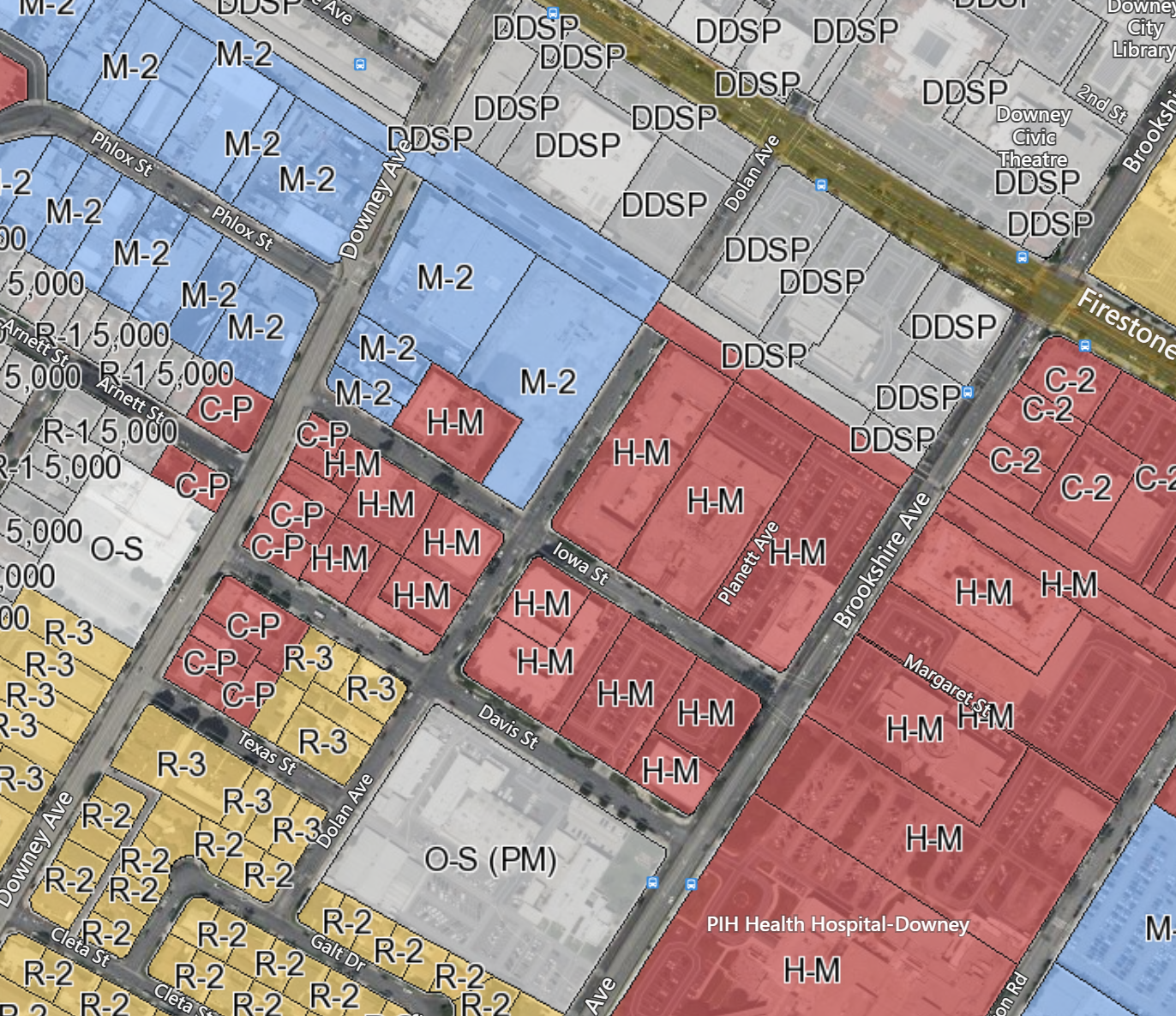
Zoning Boundary
Zoning Boundary layer (polygon) is provided for mapping and analytic purposes. It carries a narrower set of fields focusing on the zoning type, code, and description. We also include the zoning category that normalizes the data for cross jurisdiction queries.
Pro Tip:
As mentioned above there are no field level indexes provided out of the box. If you are querying on a field most of the time, it is best practice to apply a field index on that field for better query performance.
Zoning boundary fields
| Field Name | Description | Data type | Example |
|---|---|---|---|
| ZONING_BOUNDARY_ID | Unique ID for the zoning boundary | ||
| STATE_ABV | State abbreviation | string | CA |
| ZONING_TYPE | type of zoning boundary, Base or overlay (from zoning boundary). | string | Base |
| ZONING_CODE | Zoning code | string | R-80 |
| ZONING_CODE_UNFORMATTED | unformatted zoning code | string | r80 |
| ZONING_CATEGORY | LightBox standardized zoning category | string | |
| ZONING_DESCRIPTION | Description of zoning code | string | Neighborhood Commercial District |
| BOUNDARY_VINTAGE | Publish date of Zoning boundary when available | date | 4/20/2021 |
| GEOMETRY | Zoning polygon Geometry | geometry |
Zoning Coverage
Zoning Coverage layer (polygon) is provided to give you an idea of our coverage.
Zoning coverage fields
| Field Name | Description | Data type | Example |
|---|---|---|---|
| JURISDICTION_ID | GEO_ID of the governing jurisdiction | string | 0644000 |
| STATE_ABV | State abbreviation | string | CA |
| JURISDICTION_FULL_NAME | Jurisdiction name | string | Los Angeles |
| JURISDICTION_TYPE | Jurisdiction type | string | city |
| ORDINANCE_COVERAGE | Flag fields for zoning ordinance data coverage: 'YES' - LightBox has zoning data for this jurisdiction. 'NO' - LightBox don't have zoning data for this jurisdiction. 'PARTIAL' - LightBox has part of zoning data for this jurisdiction. 'UNZONED' - LightBox confirmed that this jurisdiction has no zoning governance. | string | YES |
| ZONING_MAP_COVERAGE | Flag fields for zoning map coverage: 'YES' - LightBox has zoning data for this jurisdiction. 'NO' - LightBox don't have zoning data for this jurisdiction. 'PARTIAL' - LightBox has zoning data for part of this jurisdiction. 'UNZONED' - LightBox confirmed that this jurisdiction has no zoning governance. | string | YES |
| GEOMETRY | Jurisdiction Geometry | geometry |
Was this article helpful?