Working with the Building to Parcel Relationships
- Print
- DarkLight
- PDF
Working with the Building to Parcel Relationships
- Print
- DarkLight
- PDF
Article summary
Did you find this summary helpful?
Thank you for your feedback!
Introduction
Within the LightBox SmartFabric Core and Premium products the following is provided, a parcel layer, a building layer and a building to parcel relation table. Understanding how to use these datasets will provide a better data experience.
Building and Parcel layer overview
The parcel and the building polygon layers are sourced and/or created separately. Due to data differences the data does not always perfectly align. Alignment is also affected by real world situations such as a building right up against a property line, or a building crossing into two parcels.
Methodology
LightBox methodology is to provide the relationships that arise in these cases along with metadata that allows the choice of what is best in your situation. A key metadata field BUILDING_OVERLAP_RATIO will help you decide if the building is truly within the parcel or not. Refer to the example screenshots below:
Example 1:
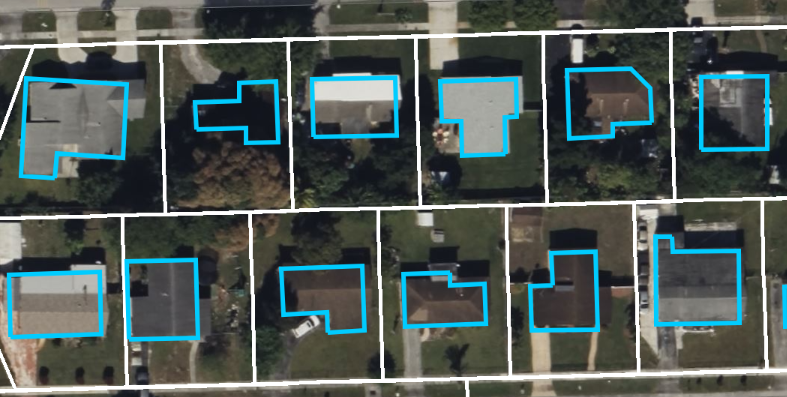 Standard Case where the building is completely inside a parcel In this standard case you will see that all buildings reside completely within the parcel. There will be a single entry in the BuildingParcelRelation table with one PARCEL_LID and ONE BUILDING_LID AND BUILDING_OVERLAP_RATIO of 100.
Example 2:
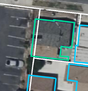 Case where the building is slightly over one of the parcels.
 In the case where the building is slightly over a parcel there will be two records in the BuildingParcelRelation table, each record will have the same BUILDING_LID and each record having a different PARCEL_LID. Each record will also have a different BUILDING_OVERLAP_RATIO. The record with the majority of the building would be something like 96 and the one with the other record having 4 making up a 100.
Pro Tip
As seen in the example above the record that has a BUILDING_OVERLAP_RATIO = 4 should not be included in the result. The BUILDING_OVERLAP_RATIO can be used to filter out records based on your use case. An example might be to filter out records that are >= 15
Example 3:
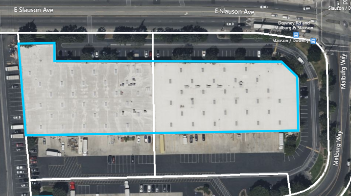 Case where the singe building straddles two parcels and is valid
In the case where it is valid to straddle two parcels there will be two records in the BuildingParcelRelation table, each record will have the same BUILDING_LID and each record having a different PARCEL_LID. Each record will also have a different BUILDING_OVERLAP_RATIO. In this case the BUILDING_OVERLAP_RATIO for one record may be 45 and the other record has a BUILDING_OVERLAP_RATIO of 55. It is perfectly valid to have this case in your data and you would return both parcels.
Example 4:
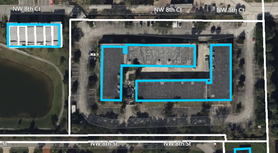 Case of a many to one relationship
In this case there is a many-to-one relationship with a single parcel. Here there are two records in the BuildingParcelRelation table, each record will have the same PARCEL_LID and each record having a different BUILDING_LID.
BuildingParcelRelation
Description: This table can be used to create a relationship/join with the building table to the parcel table.
Allows you to:
- Return all parcels that are associated with a building record.
- Return all building records associated with a parcel record.
- Return all buildings that share the same parcel record, from a building record.
Relationship: The relationship is Many building records Many parcel records.
| Field Name | Data Type | Length | Description |
|---|---|---|---|
| ADDRESS_LID | String | 50 | A proprietary LightBox ID for address that is unique and persistent. |
| PARCEL_LID | String | 50 | A proprietary LightBox ID for assessor record that is unique and persistent. |
| OVERLAP_AREA | Integer | int | Building and parcel intersection area. |
| BUILDING_OVERLAP_RATIO | Double | float | Building and parcel intersection area divided by building area. |
| PARCEL_OVERLAP_RATIO | Double | float | Building and parcel intersection area divided by parcel area, |
| FIPS_CODE | String | 5 | The 5-digit FIPS Code where the first two digits identify the state and the last three digits identify the county. |
Was this article helpful?