Structures Overview
- Print
- DarkLight
- PDF
Structures Overview
- Print
- DarkLight
- PDF
Article summary
Did you find this summary helpful?
Thank you for your feedback!
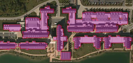 A building footprint is a polygon, or region object, that describes the physical, two dimensional extent of any building or structure. A building footprint can represent a traditional single family home, a business, a shopping mall, a mobile home, an apartment building, a large parking garage or detached family garage, an oil storage tank, or nearly any other manmade physical feature found in the world.
With the associated address information tied to each building footprint you can geocode and reverse geocode, or link to any other dataset that contains an address – demographics, business list, real property data, and more.
A Base Layer
The LightBox Structure boundary data is a critical base layer for the LightBox SmartFabric™ dataset. Where parcel boundaries provide the container for the property, structure boundaries provides precise location awareness of the habitable and the built world.
LightBox ID
The LightBox identifier is a permanent and universal identifier for data that creates powerful connections to LightBox’s information model. Our Structure dataset supports this ID and is available through the structure API and SmartFabric™ data package. Using the LightBox ID one can walk the full property graph.
.PNG)
Was this article helpful?