LightBox Zoning
- Print
- DarkLight
- PDF
LightBox Zoning
- Print
- DarkLight
- PDF
Article summary
Did you find this summary helpful?
Thank you for your feedback!
LightBox Zoning Data Set
Gain a more complete picture of parcels with deeper zoning data from one source.
 Zoning Matters!
Overview
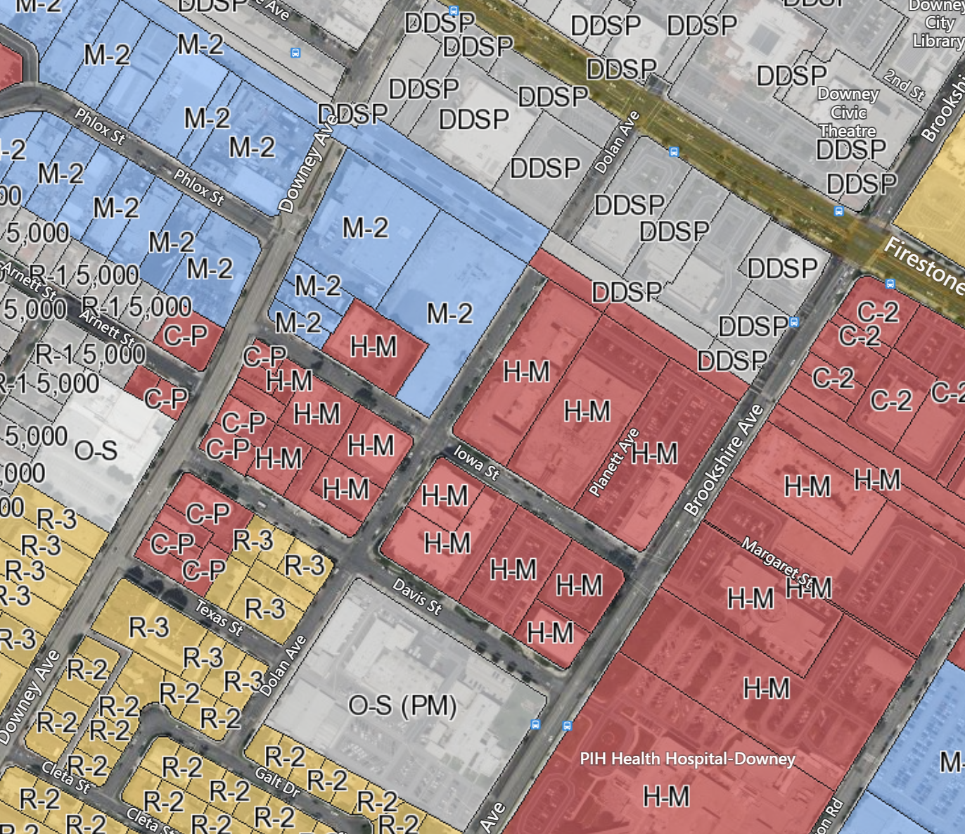
Zoning data is a critical component in property due-diligence. Source all the information you need on a national level with LightBox Zoning Data. LightBox zoning data can help you find everything from what a property is zoned for, to zoning districts, setback requirements, floor area ratio (FAR), building height, and more right at your fingertips in one convenient place. No more trips to the planning office, or hours poring over tedious zoning websites for the information you need, which will save you valuable time and resources.
Make faster, smarter decisions
Gain a better understanding of zoning setbacks, lot area, density, and other attributes for a property. Plus, get a deeper view of complementary zoning for your project with the ability to look at surrounding areas.
Avoid costly mistakes
Having trusted zoning data can help avoid scenarios such as finding out neighboring zoning is at odds with a project can adversely affect your financials.
Get accurate information for greater success
The most accurate information ensures you make better decisions about market approaches and product creation.
Flexible delivery options
The zoning data package is available via an add-on to SmartFabric data package, API and our SaaS applications.
Data Collection
LightBox Zoning data is collected at the jurisdiction level on a national scale.
Our dedicated zoning data acquisition team researches the jurisdictions in a target area one-by-one, by working with the jurisdiction zoning department to collect its zoning ordinance and zoning map.
Ordinance data for each zoning code in a jurisdiction is then mapped into the LightBox standard schema with the original jurisdiction field name logged as the corresponding ‘_LABEL’ field.
The ordinance source URL is also provided to users for reference. When a zoning map source is located, the fields in the map are mapped into the LightBox standard schema.
All jurisdictions’ zoning maps are combined into one dataset to form the zoning boundary layer. Additionally, it is overlaid with parcel data in-house so that a zoning code can be returned via the Parcel LightBox ID.
Coverage
LightBox currently focuses on building zoning coverage in the top 50 MSAs and areas with high transaction activity. The LightBox zoning data acquisition team continues to expand our zoning coverage while at the same time maintain its currency.
Zoning data update targets are based on a jurisdiction population size. For jurisdictions with population larger than 100k, it is updated every quarter and jurisdictions with population lower than 100k, it is updated every other quarter.
More Information
Was this article helpful?