Addresses FAQ
- Print
- DarkLight
- PDF
Addresses FAQ
- Print
- DarkLight
- PDF
Article summary
Did you find this summary helpful?
Thank you for your feedback!
Q: Why does the assessment and address datasets both have addresses?
A: The assessment layer contains situs addresses only and the address layer contains all the possible address, both situs and secondary addresses. Please see Situs vs Secondary Addresses
Q: Are there regional or situational differences in Address Confidence Scores?
A: The distribution of Address Confidence Scores (ACS) at the county level has a direct relationship with the percentage of primary and secondary addresses in a given county which is in turn related to county population. This may mean that when considering use thresholds for address confidence scores, these may need to be adjusted to account for any skews in scores.
Q: What can influence the differences in Address Confidence Scores?
A: In general, it has been found that counties with higher rates of seconday addresses tend to skew toward lower address confidence scores which may be a result of inflated number of units in certain data sources.
A high percentage of secondary addresses is also associated with larger populations meaning that urban areas may see this type of skew. Conversely, counties with lower rates of secondary addresses (i.e. more primary addresses) tend to skew toward higher address confidence scores.
Lower rates of secondary addresses are associated with smaller populations which would indicate that rural counties are more likely to have scores that are skewed toward high values.
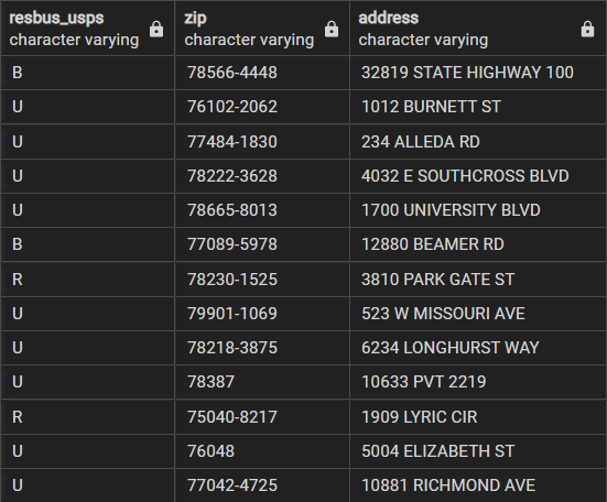
Q: What is the RESBUS_USPS attribute?
A: The USPS ResBus (Residential or Business) indicators are attributes provided by the United States Postal Service (USPS) indicating if an address is classified as residential (R) or business (B). Addresses that are neither residential or business are classified as unknown (U). The indicators are helpful in multiple applications including marketing or logistics, USPS uses this attribute for package delivery pricing. USPS regularly updates this indicator as they collect and verify address information.
LightBox leverages this attribute to encode each address with a basic notion of what is at the address. The reliability of this attribute is high and is carried through into our SmartFabric Address and Location layer as 'resbus_usps'.
Lightbox also uses this indicator as part of the processing for creating the Residential Unit Counts, aiding in the classification of the unit counts.
Q: Have you included Non-USPS-recognized addresses in the address file?
A: Yes and you can identify these addresses by reviewing their zip code. Non-USPS-recognized addresses will only have a 5 digit ZIP and not a full ZIP+4. Out of the 250 million records in our nationwide Addresses file, approximately 20 million of the addresses are non-USPS recognized.
There are many reasons why we would have addresses that do not turn out to be USPS recognized/validated:
- Addresses for unbuilt land.
- Addresses in areas that haven't been reviewed and classified by the USPS.
- Addresses in areas where postal delivery is done at postal boxes or an aggregator location where the USPS does not bother to validate (and assign ZIP+4s) the accompanying non-delivery addresses.
- Addresses that are off the grid.
- Addresses that are mostly good addresses however they are malformed enough that we can not confidently validate them.
Q: Have you classified Non-usps addresses classified in the resbus_USPS field? Or are these defaulted as an 'Unknown' category?
A: Non-USPS validated addresses will have a ResBus_USPS value = "U".
Q: What happens if the address is not USPS validated?
A: In instances where an address is not USPS-validated, that address is assigned a 'resbus_usps' value of "U(nknown)" by default.
Note:
That while this is the default value for addresses that are not USPS-recognized, USPS-recognized addresses can also have "U" assigned to them by USPS.
Q: What is an "address" comprised of in SmartFabric?
A: An address is used to describe any location – a house, an apartment, a store, an empty plot of land, a destination – for the purposes of finding, determining a path to or from, analyzing or getting context on a location.
Addresses are comprised of:
- House numbers
- Street names
- Unit information (if applicable)
- City
- State
- Postal Code
Definitions:
- Base Address - 123 Example St.
- Secondary Unit Address - 123 Example St, Ste 222
Q: What does "Validation and Standardization" mean in SmartFabric?
A: One thing to note, an address can be standardized but note validated, but all validated addresses are standardized.
- Standardizing an address: Ensuring an address is in a format that adheres to recognized conventions.
- Validating an address: Determining if the address is recognized by a postal authority (US Postal Service). The USPS has an official program for validating addresses known as CASS.
- LightBox standardizes and validates all address information using USPS and Canada Postal information. (Currently North American coverage)
| Example of an input address: 123 South 36 th Avenue | What was the process?
|
| Standardized and Validated address: 123 36TH AVE S APT 216 FARGO ND 58104-5164 |
Q: Which SmartFabric address components are found in which packages?
A: This answer can be address at several levels:
- Address Point Layer (SmartFabric Professional and Core bundles)
- 255+ million points
- All addresses currently available to LightBox
- Situs Address (All SmartFabric bundles)
- An address associated with the assessor record - the "Site Address" of the parcel.
- Approximately 157 million assessor records, 138 million have Situs Address
- Owner Address, also referred to as Mailing Address (All SmartFabric bundles)
- An address in the assessor record indicating where tax bills are mailed to the owner.
- Frequently Owner Address is not equal to Situs Address (not owner-occupied, commercial property).
- Approximately of the 157 million assessor records, 154 million have a Mailing Address.
Q: What makes up the SmartFabric Address Point Layer?
A: LightBox draws from several sources of address information and combines these sources to create the most complete address system. These sources include:
- Spatial Sources - data sources where addresses include a Latitude/Longitude
- LightBox Situs Address content - 138 million parcel-linked addresses.
- E911 high quality sources that support local 911 operations.
- Address sources built by local GIS teams to support analysis.
- HERE spatial data to provide additional content not found from other sources.
- Non-Spatial Sources - data sources with no geographic reference
- US Postal Service data - recognized addresses and secondary units that come with address metadata such as a residential/business indicator.
- Consumer list data - lists of addresses that appear in a consumer database we utilize for "address signal'.
Q: What is the address and geometry difference between SmartFabric and Situs addresses?
A: Our goal is to have as many addresses as possible be "Rooftop Accurate" over "Parcel Centroid Accurate. Meaning the point on a map identifying the parcel falls on the building/structure footprint on the parcel, not just the center of the parcel. 80%+ of SmartFabric addresses are rooftop accurate.
Situs addresses have their location at the center of the parcel - Parcel Centroid Accurate. | SmartFabric addresses have their location at the center of the building footprint (when applicable) - Rooftop Accurate. |
The goal is to help identify all the secondary units within a building for both residential and commercial buildings. When possible, a sub-building location for secondary addresses or units are provided.
Secondary Units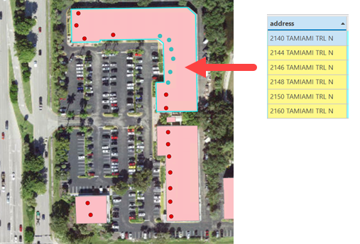 | Secondary Addresses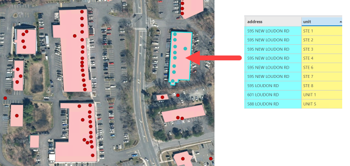 |
Q: How is ADDRESS_LID determined?
A: ADDRESS_LID utilizes the address, unit, and 5-digit postal code of the standardized address.
Q: What is the difference between PRIMARY_ADDRESS_LID, ADDRESS_LID and PRIMARY_ADDRESS_LID?
A: Answer:
- PARENT_ADDRESS_LID = the lowest alphanumeric address associated with a building. Can be unit-ed or unit-less.
- ADDRESS_LID = the address_lid of the address record in view.
- PARENT_ADDRESS_LID = the lid of a unit-less address that shares the same main address portion (excluding the unit) as a unit-ed address.
Q: Why is PARENT_ADDRESS_LID only seen in the Address table and not in other tables (such as the Buildings table)?
A: The parent address variable is only associated with an address. If you are interested in buildings that contain a parent address, you can use the building_address_relation table to link the address_lid where parent_address_lid is not null.
Q: Will the x/y locations of an address change over time and why would they change?
A: Yes, there always is the potential for addresses to change location.
There are several types of change that can happen:
- Small changes due to a methodology change - you may see a rooftop-accurate address change location to a slightly different location within the building due to a change that we make in determining the location.
- Promotion in accuracy of an address due to better address source information - an address might be a parcel centroid location and we can make it more accurate because of an additional e911 address source that we now use, or we now have a building footprint that did not exist before.
- Promotion in accuracy of an address due to construction - it is common for parcel centroid addresses to be assigned to yet-to-be-developed land that is eventually developed and we now have a building footprint so that we can assign the address to rooftop accuracy.
Q: Is your address data validated? Is you address data standardized?
A: Answer
LightBox:
- Validates and standardize addresses against USPS.
- Adds a ZIP+4 from USPS.
- Adds in a business/residential indicator for each address that we can validate (USPS keeps track of that indicator and we leverage it).
- Adds in secondary unit information from USPS, e.g. if we know a building is 10 Main St and USPS indicates that "10 Main St is 12345-6789, 10 Main St, APT A-D" we can add in those 4 secondary units to the building.
Q: What about addresses that do not have parcels?
A: Yes, there are addresses that we cannot reliably link to a building and a parcel and we put those addresses into SmartFabric as “unmatched address points” with no linkages at all.
Q: How do we standardize addresses? What rules are used, are there dictionaries?
A: We currently make use of a USPS-certified address processing (validation and hygiene) using a commercial partner that is an expert in this area. Every address source that we utilize passes through this process. We do, occasionally, unwind certain decisions that are performed in address processing when the results may be good for a postal/mailing engine but bad for a geospatial address fabric.
Q: We noticed that the number of digits in both variables within the Address table and GeoCoder can vary. Why is there a variation in the digit length across variables?
Example:
Address | Address Table Latitude | Address Table Longitude | GeoCoded Latitude | GeoCoded Longitude |
11211 NE WEIDLER ST | 45.5347945 | -122.5465675 | 45.534794 | -122.546568 |
8338 N INTERSTATE AVE | 45.5834781461822 | -122.684389716282 | 45.583478 | -122.68439 |
A: There are a couple of reasons for this, first our addresses come from many sources and they vary on the level of precision provided by our sources, and second our geocoder will rounds our coordinates to 6 decimal places.
Was this article helpful?