Zoning Data
- Print
- DarkLight
- PDF
Zoning Data
- Print
- DarkLight
- PDF
Article summary
Did you find this summary helpful?
Thank you for your feedback!
Introduction
Zoning information plays a critical role in any decision-making process in the Real Estate market. LightBox Zoning data is a national level zoning dataset that is connected to each location in SmartFabric.
Zoning provides insights into:
A properties zoning requirements
Zoning districts
Setback requirements
Density/Floor area ratio (FAR) requirements
Building height requirements
Permitted uses
Governing Jurisdiction information
Zoning Data Package made up of 3 components:
Parcel level zoning (Zoning Table)
Zoning Boundary
Zoning Coverage
Parcel level zoning carries detailed zone information of the location where a parcel resides. It is provided in the form of a flat file in which each record identified with a Parcel_LID that allows one to link to parcel data from the same SmartFabric release.
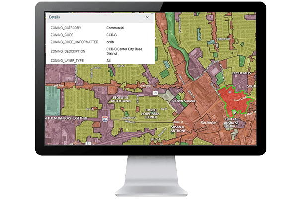
Zoning Boundary layer contains the zoning areas represented as polygons and contains the zoning code, zoning category, zoning description and jurisdiction id. This layer is designed to be used for spatial analysis with a location dataset of interest to determine zoning requirements for property locations.
Zoning Coverage contains our coverage represented as polygons. This layer can be used as a straight table using the state abbreviation and jurisdiction name to discover available coverage, or as a layer in your favorite mapping tool.
ZONING_MAP_COVERAGE - This field within the Zoning Coverage layer will let you know if we have coverage for this area. Keep in mind that we do carry a "Partial" value for this field and is used when there is only partial coverage for the area.
Product Description
Coverage
LightBox currently focuses on building zoning coverage in the top 50 MSAs and areas with high transaction activity. The LightBox zoning data acquisition team continues to expand our zoning coverage and at the same time maintain its currency.
For each release, we will maintain a summary of data coverage within the release notes. You can find the detailed coverage information through the Zoning coverage map.
Update cycle
Zoning data update targets are based on jurisdiction’s population size. For jurisdictions with population greater than 100k, updated every quarter and jurisdictions with population less than 100k, updated every other quarter.
Release cycle
LightBox zoning data will be released once a quarter. It will be paired with a parcel version of SmartFabric from the same quarterly release. This ensures that the Zoning Table matches up with the SmartFabric Parcel layer.
Flexible delivery options
The zoning data package will be available via an add-on to SmartFabric data package, API and our SaaS applications.
Data Collection
LightBox Zoning data is collected at the jurisdiction level on a national scale. Our dedicated zoning data acquisition team researches the jurisdictions in a target area one by one by working with the jurisdiction zoning department to collect its zoning ordinance and zoning map.
Ordinance data for each zoning code in a jurisdiction is then mapped into LightBox standard schema with the original jurisdiction field name logged as the corresponding ‘_LABEL’ field.
The ordinance source URL is also provided to users for reference. When a zoning map source is located, the fields in the map are mapped into LightBox standard schema.
All jurisdictions’ zoning maps are combined into one dataset to form the zoning boundary layer. Additionally, we overlay it with parcel data in-house to so that a zoning code can be returned via the Parcel LightBox ID.
Important Links & Downloads
Was this article helpful?